


Le Pradet la colle noire et ses forts

bernir
User
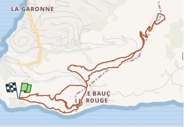

Length
8.4 km

Max alt
283 m

Uphill gradient
341 m
Km-Effort
13 km

Min alt
14 m

Downhill gradient
341 m
Boucle
Yes
Creation date :
2020-01-15 11:34:30.444
Updated on :
2020-01-24 10:07:51.982
4h44
Difficulty : Easy

FREE GPS app for hiking
 SityTrail
IGN / Geographical institutes
SityTrail Plus
The world is yours!
About
Trail Walking of 8.4 km to be discovered at Provence-Alpes-Côte d'Azur, Var, Le Pradet. This trail is proposed by bernir.
Positioning
Country:
France
Region :
Provence-Alpes-Côte d'Azur
Department/Province :
Var
Municipality :
Le Pradet
Location:
Unknown
Start:(Dec)
Start:(UTM)
257709 ; 4773999 (32T) N.
Comments